A complete 6-day trekking guide to ABC (4,130 m) – day-by-day itinerary, elevation data, September packing list, Gurung cultural heritage, wildlife, permits, and a post-trek Pokhara recovery guide. Written by a local guide with first-hand experience on this route.
Summit Elevation4,130 m
Total Distance65 km
Duration6 Days
DifficultyModerate
Best SeasonSep–Nov
↓ Begin the ascent
Quick Summary: The Annapurna Base Camp Trek is a 65 km, 6-day moderate trek from Pokhara reaching 4,130 m inside the Annapurna Sanctuary – a glacially carved amphitheater enclosed by eight peaks above 6,000 m, including Annapurna I (8,091 m), the world’s tenth-highest mountain. September offers lush monsoon landscapes and powerful waterfalls; October-November delivers the clearest mountain visibility of the year. Requires an ACAP Permit (NPR 3,000) and TIMS Card (NPR 2,000).
Essential Information
ABC Trek – At a Glance
Starting Point
Jhinu Danda via Pokhara Lakeside (800 m)
Summit
Annapurna Base Camp (4,130 m)
Machhapuchhre Base Camp
3,700 m – Day 4 lunch stop
Total Distance
~65 km over 6 days
Difficulty
Moderate – suitable for fit beginners
Best Seasons
Spring (Mar–May) & Autumn (Oct–Nov)
September Conditions
Transitional – lush but wet; leech-active below 2,500 m
Permits
ACAP (NPR 3,000) + TIMS Card (NPR 2,000)
Accommodation
Teahouses throughout; no camping required
Trailhead
Jhinu Danda – 3 hr drive (58 km) from Pokhara
Protected Area
Annapurna Conservation Area (ACAP) – 7,629 km²
ABC Managed By
NTNC (National Trust for Nature Conservation)
Personal account – local guide with first-hand experience on this route. Conditions verified September and autumn seasons.
Most treks offer you a mountain to look at. The Annapurna Sanctuary offers something rarer: a mountain to stand inside.
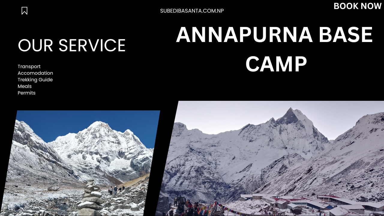
The difference becomes clear the moment you crest the ridge above Machhapuchhre Base Camp (3,700 m) and the Sanctuary opens around you. This is not a viewpoint. It is a glacially sculpted basin – the Annapurna Sanctuary – enclosed on all sides by a continuous wall of peaks: Annapurna I (8,091 m, the world’s tenth-highest mountain and one of the most technically demanding 8,000 m summits), Annapurna South (7,219 m), Gangapurna (7,455 m), Hiunchuli (6,441 m), and the sacred, unclimbed spire of Machhapuchhre (6,993 m), whose twin summits give it the name Fishtail. Standing at Annapurna Base Camp (4,130 m) at dawn, with the first light firing the peaks orange above the South Annapurna Glacier, you understand why this approach is called the greatest mountain amphitheater on Earth. You can find me on different Travel Directory like Travel and Tourism Directory.
This guide covers the full 6-day route in detail – with particular attention to September, the monsoon-to-autumn transition that most trekking guides barely address. September is genuinely different from October: the rhododendron forest between Chhomrong and Bamboo runs with waterfalls, the Bamboo grove glitters after rain, and the lower trail demands leech gaiters and a rain shell. It is messier, louder, and more alive than autumn – and for the right trekker, considerably more rewarding.
Route Elevation Profile
Waypoints, Elevations & Daily Data
| Day | Route | Distance | Time | Elevation | Notes |
| Drive | Pokhara → Jhinu Danda | 58 km | ~3 hrs | 1,780 m | Jeep; Modi River crossing |
| Day 1 | Jhinu → Chhomrong | 3 km | ~2.5 hrs | 2,170 m | Gurung gateway; first Annapurna South views |
| Day 2 | Chhomrong → Dovan | 11 km | ~6 hrs | 2,520 m | Chhomrong Gumba; Selbu Bridge; Bamboo forest |
| Day 3 | Dovan → Deurali | 7 km | ~4 hrs | 3,230 m | Treeline transition; Himalayan Hotel lunch |
| Day 4 | Deurali → MBC → ABC | 8 km | ~5 hrs | 4,130 m ↑ | MBC (3,700 m) lunch; Buddha rock formation; frozen ponds |
| Day 5 | ABC → Bamboo | 13 km | ~6 hrs | 2,310 m ↓ | Glacial sunrise; South Annapurna Glacier view; long descent |
| Day 6 | Bamboo → Jhinu → Pokhara | 11 km + drive | ~5 hrs + 3 hrs | 1,780 m ↓ | Jhinu hot springs; celebratory lunch in Chhomrong |
The 6-Day Sanctuary Itinerary
Day 1 – Gateway to the Gurungs/Jhinu Danda → Chhomrong (2,170 m)
Distance3 km
Walking Time~2.5 hrs
End Elevation2,170 m
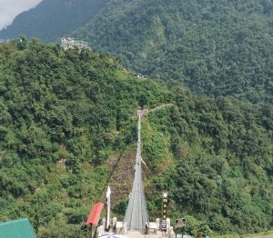
The journey begins not on foot but on water – crossing the suspension bridge over the Modi Khola (Modi River) at Jhinu Danda (1,780 m), where the gorge is deep enough that the sound of the river disappears entirely in the canopy below. In September, the Modi runs chocolate-brown with monsoon silt, fast and loud, and the spray from the bridge cables is cold enough to feel like the mountains are introducing themselves.
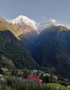
The 3 km ascent to Chhomrong (2,170 m) is short but steep – the first of several encounters with the famous stone stairways of the Annapurna Sanctuary trail, carved directly into the hillside by generations of Gurung and Magar communities. Chhomrong itself is one of the finest surviving examples of a traditional Gurung (Tamu) settlement in the Pokhara Valley – its stone houses arranged along the ridge, the Chhomrong Gumba visible above, and the first unobstructed panorama of the trek appearing without warning as you crest the final steps: Annapurna South (7,219 m), Hiunchuli (6,441 m), and the impossibly photogenic spire of Machhapuchhre (6,993 m), simultaneously close and unreachable.
 Guide’s Tip – Day 1
The Chhomrong Gumba (monastery) above the main village is worth 20 minutes of your afternoon. The resident monks can explain the relationship between the Gurung community’s traditional Pye Lhu Srinmu shamanism and the Tibetan Buddhist practice that arrived in the valley later – two spiritual systems that coexist here as naturally as rhododendron and oak.
Day 2 – Into the Green/Chhomrong → Dovan (2,520 m)
Distance11 km
Walking Time~6 hrs
End Elevation2,520 m
This is the most biologically dense day of the trek – and in September, the most visually overwhelming. The descent from Chhomrong drops back through the Selbu Bridge crossing before climbing into the forest corridor that defines the mid-elevation Sanctuary approach: dense stands of Rhododendron arboreum (Nepal’s national flower, crimson-blooming in spring), Rhododendron campanulatum above 2,500 m, and bamboo (Himalayacalamus falconeri) thickets that give the settlement of Bamboo its name. In September, the canopy drips continuously after morning rain, and the air carries the compound smell of wet moss, decaying leaves, and something floral that I’ve never been able to identify precisely.
The Himalayan Monal (Lophophorus impejanus) – Nepal’s national bird, iridescent green and copper across the male’s back – is regularly seen crossing open sections of trail between 2,100 m and 3,500 m, most often in the early morning before the valley mist burns off. The route also passes through habitat for the Kalij Pheasant (Lophura leucomelanos) in the lower bamboo zones, whose alarm call – a sharp, descending whistle – is often the first sign of wildlife before the bird itself appears.
Guide’s Tip – Day 2 (September Specific)
Below Sinuwa and through the Bamboo section, leeches are active in early September after rain. Salt in a small container or commercial leech repellent applied to boot seams and gaiters is far more effective than trying to remove them mid-walk. Check exposed skin at every rest stop. This is not dramatic – it is simply part of trekking in the monsoon transition – but it is a reality most September guides omit.
Day 3 – The Alpine Shift/Dovan → Deurali (3,230 m)
Distance7 km
Walking Time~4 hrs
End Elevation3,230 m
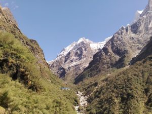
Day 3 is the day the forest releases you. The trail climbs out of the bamboo-rhododendron zone and into the upper Sanctuary corridor, where the vegetation thins, the temperature drops noticeably with each 100 m gained, and Machhapuchhre begins to dominate the skyline ahead in a way that feels almost architectural – the twin summits of the Fishtail visible for the first time as a complete silhouette, unobscured by canopy.
The transition from forest to alpine scrub above 3,000 m is one of the most abrupt ecological boundaries on the route. The dense birch (Betula utilis) and juniper (Juniperus recurva) zone gives way within a few hundred metres to the open rocky terrain that characterises the upper Sanctuary approach. At Himalayan Hotel (2,920 m), a lunch stop allows time to observe the waterfalls coming off the rock walls above – at their most powerful in September, when the monsoon drainage from the upper cirques runs in multiple braided streams down the valley walls. At Deurali (3,230 m), the Sanctuary proper begins: the walls close in, the sky narrows, and the temperature at evening can drop below 0°C even in September.
Guide’s Tip – Day 3
Monitor for AMS (Acute Mountain Sickness) symptoms from Deurali onward. Headache, loss of appetite, and disrupted sleep at this elevation are common and manageable with rest and hydration. The standard rule applies: never ascend to sleep at a higher elevation if you have a persistent headache. Diamox (acetazolamide) at 125 mg twice daily from Day 2 is worth discussing with your doctor before departure if you have a history of altitude sensitivity.
Day 4 – The Heart of the Sanctuary/Deurali → MBC → Annapurna Base Camp (4,130 m)
Distance8 km
Walking Time~5 hrs
End Elevation4,130 m
MBC Lunch Stop3,700 m
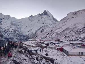
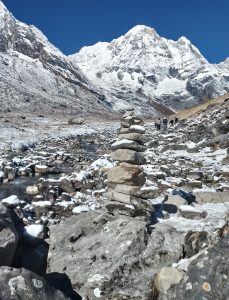
This is the day everything the trek has been building toward arrives simultaneously. The route from Deurali to Machhapuchhre Base Camp (MBC, 3,700 m) passes through the narrow upper entrance of the Sanctuary, where the valley walls compress to a corridor before opening – suddenly, without warning – into the full 360-degree amphitheater above. The Sanctuary is not a gradual revelation. It is a door that opens.
On the upper cliffs approaching MBC, a rock formation in the cliff face creates a shadow profile that local Gurung and Magar guides have long described as resembling a recumbent figure of the Buddha – visible when the morning light strikes the cliff at a low angle, most clearly in September and October when the sun tracks lower in the sky. It is one of those details that divides trekkers: some see it immediately; others not at all. Worth slowing down for, regardless of the outcome.
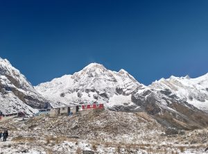
After lunch at MBC, the final 430-metre climb to ABC (4,130 m) passes frozen ponds and the lateral moraine of the South Annapurna Glacier. The moment of arrival at Annapurna Base Camp – when the full encircling wall of peaks is simultaneously visible – is genuinely unlike anything else in Himalayan trekking. The amphitheater contains Annapurna I (8,091 m), Annapurna South (7,219 m), Annapurna III (7,555 m), Gangapurna (7,455 m), Hiunchuli (6,441 m), and Machhapuchhre (6,993 m). You are standing on the floor of a cirque formed by eight peaks above 6,000 m. Take time with it.
Guide’s Tip — Day 4
Arrive at ABC by 3 PM if possible and spend the remaining afternoon simply observing how the light moves across the amphitheater. The peaks change colour continuously from mid-afternoon through sunset – ochre, then copper, then deep rose – and the sequence is different every visit. The morning sunrise is justifiably famous, but the evening light on Annapurna South from ground level is arguably the more intimate spectacle.
Day 5 – The Glacial Dawn/ABC → Bamboo (2,310 m)
Distance13 km
Walking Time~6 hrs
Descent−1,820 m
Wake before dawn. At ABC (4,130 m), the first light arrives not as a gradual brightening but as a sudden illumination – the peaks ignite from the top down as the sun clears the eastern ridgeline, and for approximately eight minutes, the entire amphitheater glows in shades of gold and copper before settling into the stark white-and-blue clarity of high-altitude day. The South Annapurna Glacier, partially visible from the viewpoint above camp, is a reminder that this landscape is still actively shaped by ice – the glacier has retreated measurably in recent decades, a fact now documented in ACAP conservation reports.
The 13 km descent to Bamboo is long and rewarding in different ways – lungs back at full pressure, legs moving efficiently downhill, the vegetation reappearing zone by zone as you lose altitude. The forest feels completely different on the descent: familiar landmarks seen from a new angle, the light lower and warmer in the afternoon. Rest at Deurali for lunch before the final section into Bamboo, where the teahouse is surrounded by the same birdsong that made Day 2 so memorable – the full circle of the Sanctuary experience closing quietly in the trees.
Day 6 – The Great Soak/Bamboo → Jhinu Danda → Pokhara
Distance11 km
Walking Time~5 hrs
Drive Back~3 hrs
The final day retraces the lower route through Chhomrong – where lunch offers a last panorama of the peaks and a chance to thank whoever in the kitchen has been feeding you for six days — and descends to Jhinu Danda and its natural hot springs. The springs sit directly above the Modi Khola, their water geothermally heated and consistently around 40–42°C: exactly the temperature that 65 km of mountain walking requires. Soak for at least an hour. There is no better way to close an alpine chapter than horizontal, warm, watching the river below.
The three-hour jeep drive back to Pokhara passes quickly. The city arrives with the specific shock of traffic and noise that follows six days of trail silence – disorienting for an hour, then immediately comfortable. Pokhara is one of the finest post-trek cities in South Asia, and you have earned its pleasures completely.
Guide’s Tip — Day 6
Jhinu hot springs has a small fee (NPR 200–300) and can be crowded on weekends. Arrive by 2 PM for the quietest experience. The lower pool, closer to the river, is cooler and better for a long soak. The upper pool runs hotter – good for the first 15 minutes, less comfortable beyond that.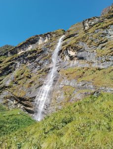
Ecosystem & Heritage
Wildlife, Flora & Gurung Culture in the Sanctuary
The Annapurna Conservation Area (ACAP) – established in 1986 and covering 7,629 km² – is managed by the National Trust for Nature Conservation (NTNC) under IUCN Category V protected area status. The vertical range of the ABC route, from subtropical forest at Jhinu (1,780 m) to glaciated high-alpine terrain at ABC (4,130 m), compresses five distinct ecological zones into a single 6-day journey.
 Flora Along the Route
Tree RhododendronRhododendron arboreumNepal’s national flower. Crimson blooms at 2,000–3,000 m in spring. Dominant in the Chhomrong–Bamboo corridor year-round.
Bell RhododendronRhododendron campanulatumWhite-violet blooms above 3,000 m. Covers the upper Sanctuary approach in spring.
Himalayan BirchBetula utilisWhite-barked; forms a transitional zone between rhododendron forest and alpine scrub at 3,000–3,500 m.
Himalayan BambooHimalayacalamus falconeriDense thickets at Bamboo settlement (2,310 m); provides habitat for Red Panda and numerous bird species.
Weeping JuniperJuniperus recurvaFragrant; found at 3,000–4,000 m; burned as incense in Sanctuary teahouses and gompas.
 Wildlife in the ACAP Zone
Himalayan MonalLophophorus impejanusNepal’s national bird. Iridescent plumage; forages at 2,100–4,500 m. Common on Day 2 trail in early morning.
Red PandaAilurus fulgensEndangered. Chestnut-coated; inhabits bamboo zones at 2,200–4,800 m. Best observed at dawn near Bamboo.
Blue Sheep (Bharal)Pseudois nayaurPrimary prey of Snow Leopard. Herds visible on rocky slopes above Deurali and near MBC.
Himalayan TahrHemitragus jemlahicusReddish-coated wild goat; swept-back horns; found on rocky slopes above 2,500 m.
Kalij PheasantLophura leucomelanosCommon in bamboo-rhododendron zones; alarm call distinctive. Active in lower forest September–November.
The Gurung People of the Annapurna Corridor
The villages of Chhomrong, Chomrong, and Ghandruk along the ABC approach are among the finest living examples of Gurung (Tamu) cultural heritage in Nepal. The Gurung are a Tibeto-Burman people whose traditional spiritual practice – Pye Lhu Srinmu (Gurung shamanism) – coexists with Tibetan Buddhism in a duality visible in every village: clan shrines alongside Buddhist gompas, shamanic ritual calendars alongside the Tibetan lunar calendar. The ACAP-managed Annapurna Conservation Area has been specifically praised by UNESCO and IUCN for its model of conservation that integrates local Gurung, Magar, and Thakali community governance with wildlife protection.
Tamu Lhosar
Gurung New Year (December–January). Celebrated in Chhomrong and Ghandruk with dance, feasting, and shamanic ceremony.
Arati Ceremony
Evening fire offering at Tal Barahi Temple, Pokhara. Hindu ritual; most powerful at the Phewa Lake shore at sunset.
Buddha Jayanti
Full moon of Vesak (April–May). Butter lamp offerings at the Chhomrong Gumba and Sanctuary monasteries.
Maghé Sankranti
January harvest festival; sesame and yam dishes; celebrated in the lower-altitude Gurung villages.
Before You Go
ABC Packing List – September Edition
September is the most demanding month to pack for on the ABC route: you need gear for 30°C subtropical humidity at Jhinu and -10°C sub-zero nights at ABC (4,130 m), with sustained rain below 3,000 m and potential fresh snow above it. The list below reflects that full range.
Outerwear
-
- →Down jacket rated to −10°C (essential above Deurali at night)
-
- →Waterproof rain shell or poncho (non-negotiable for September – pack both for heavy rain days)
-
- →Fleece mid-layer for evenings at Chhomrong and above
-
- →Lightweight base layer (moisture-wicking; essential on Day 2 climbs)
Footwear & Poles
-
- →Sturdy ankle-support trekking boots (the Chhomrong stone stairs demand lateral stability)
-
- →Trekking poles – mandatory for the Chhomrong stairway descent and the 13 km Day 5 return
-
- →Leech gaiters or salt for lower trail (Bamboo section, September)
-
- →Crampons or micro-spikes if ABC has fresh snow (possible September–October)
Sleep & Health
-
- →Sleeping bag rated to −15°C (teahouse blankets inadequate at ABC in September)
-
- →Hot water bottle for cold teahouse nights (fill at dinner; sleep warmer)
-
- →Diamox (acetazolamide) for AMS – discuss 125 mg twice daily with your doctor before departure
-
- →First aid kit including blister treatment, ibuprofen, rehydration salts, and antiseptic
-
- →Water purification tablets or filter (spring water available but not always safe untreated)
Permits & Documents
-
- →ACAP Permit – NPR 3,000 (obtainable at ACAP office, Pokhara, or online via DNPWC)
-
- →TIMS Card — NPR 2,000 (Trekkers’ Information Management System; required by all trekkers)
-
- →Passport + 2× passport photos (required for both permits)
-
- →Sufficient cash in Nepali Rupees (NPR) — no ATMs beyond Pokhara; budget NPR 3,000–5,000/day for teahouse + meals
Common Questions
Annapurna Base Camp Trek – FAQ
Is the Annapurna Base Camp Trek suitable for beginners?
Yes, for fit beginners with appropriate preparation. The route involves no technical climbing, and the teahouse infrastructure means no camping gear is required. The key demands are cardiovascular fitness for the sustained uphill sections (particularly Chhomrong and the Deurali–ABC ascent) and the ability to manage altitude at 4,130 m. First-time high-altitude trekkers should allow an extra acclimatisation day at Deurali if feeling the effects of elevation, and should ascend slowly on Day 4.
How difficult are the Chhomrong stone stairs?
The Chhomrong stairway is one of the most physically demanding sections of the route – not because of altitude, but because of sheer step count. The descent from Chhomrong on Day 2 and the ascent back up on Day 6 involve several hundred stone steps, often wet and uneven. Trekking poles are strongly recommended for knee protection, particularly on the descent. Budget slightly more time than the guidebook suggests and pace yourself – rushing the stairs is where most injuries on the ABC route occur.
What is the difference between trekking ABC in September versus October?
September is the end of monsoon season: the trail is lush and green, waterfalls are at full power, and the forest between Chhomrong and Bamboo is extraordinarily alive – but rainfall is frequent and leeches are active below 2,500 m. Mountain views can be partially obscured by cloud in September, though mornings are often clear. October brings the clearest visibility of the year, dry trails, stable weather, and the rhododendron forest in its post-monsoon deep green. October is the more predictable; September is the more atmospheric.
What elevation is Annapurna Base Camp, and is altitude sickness a concern?
Annapurna Base Camp sits at 4,130 m – high enough for Acute Mountain Sickness (AMS) to affect trekkers, particularly those ascending quickly from Pokhara (800 m) in 4 days. The 6-day itinerary in this guide builds in appropriate acclimatisation, but AMS is not predictable and has no relationship to age or fitness. Key warning signs: persistent headache, nausea, loss of appetite, and disrupted sleep. The standard response is to descend immediately if symptoms worsen. Diamox (acetazolamide) is commonly used as a preventive measure; discuss with your doctor before departure.
Do I need a guide or porter for the ABC Trek?
The main ABC route is well-marked and teahouse-dense – independent trekking is possible and common. However, a local guide adds genuine value: knowledge of the Gurung cultural sites along the route (including the Chhomrong Gumba and the Buddha rock formation), ability to navigate in poor weather or low cloud, and the kind of trail-specific knowledge (when to push, when to rest, which teahouses are best) that transforms a route into an experience. Guides from Chhomrong typically charge NPR 2,500–3,500 per day; porters NPR 1,500–2,500. Both are worth the cost.
Can the ABC Trek be completed in fewer than 6 days?
Fit, experienced trekkers sometimes compress the route to 5 days by combining Day 1 and Day 2. This is physiologically manageable but removes the acclimatisation buffer at the mid-elevation camps, increases AMS risk at ABC, and eliminates the contemplative pacing that makes this trek more than an altitude exercise. The 6-day structure exists for good reasons – the Sanctuary is not a summit to bag but an environment to inhabit. Give it the time it deserves.
After the Trek
Post-ABC Recovery in Pokhara – 2026 Guide
Pokhara is one of South Asia’s finest post-trek cities. After 6 days and 65 km, here is how to decompress properly.

Rest First
Before anything else: a shower, a real bed, and 10 hours of sleep. The Lakeside district has accommodation for every budget, from backpacker lodges to lakeside resorts. Book the nicer room – you earned it.

Eat Well
Himalayan Java on Lakeside for the best espresso in Pokhara and a breakfast that will feel extraordinary after teahouse meals. Pokhara Thakali Kitchen for an authentic Thakali set – mustard greens, buckwheat bread, and local ghee – a celebratory meal rooted in the cuisine of the Mustang region.

Spiritual Close
The Arati Ceremony at Tal Barahi Temple – a small pagoda on an island in Phewa Lake – takes place at sunset and involves fire offerings, bells, and the kind of riverside devotion that closes a Himalayan chapter more completely than any hotel bar. Take a boat across the lake for the 6 PM ceremony.

Optional Rush
If six days of mountain walking has left you craving speed rather than rest: Sarangkot paragliding (30-minute flights over Phewa Lake with Annapurna views) or the ZipFlyer from Sarangkot Hill – at 1,800 m length and reaching 120 km/h, one of the longest and fastest zip lines in the world. Both are genuinely excellent in 2026.
 ACAP Permit: NPR 3,000 – ACAP Office, Pokhara or DNPWC online portal TIMS Card: NPR 2,000 – required for all trekking routes in Nepal Both require: Valid passport + passport-size photos
Final Thoughts
“You aren’t just looking at the mountains. You are standing in the centre of them.”
That is the thing no photograph of the Annapurna Sanctuary adequately conveys: the enclosure of it. Most great mountain viewpoints give you a wall to look at. ABC gives you a room to stand inside. The eight peaks above 6,000 m that form the Sanctuary’s walls are not backdrop – they are architecture. Six days to reach that room. A lifetime to remember standing in it.