Target keyword cluster: Manaslu Circuit Trek, Annapurna Circuit Trek, trekking in Nepal, Larkya La Pass, Thorong La Pass, Nepal Himalayan treks
Introduction
Nepal is home to eight of the world’s fourteen 8,000-meter peaks, and its trekking corridors rank among the most varied and dramatic on Earth. Two circuits stand out for serious trekkers: the Manaslu Circuit Trek in Gorkha District and the Annapurna Circuit Trek spanning Manang, Mustang, and Kaski districts. Both loop entirely around a Himalayan massif, both cross a high-altitude pass above 5,000 meters, and both pass through living communities shaped by Tibetan Buddhist culture – yet they deliver completely different experiences.
This guide compares these two iconic Nepal treks across difficulty, altitude risk, terrain, infrastructure, and overall experience, so you can choose the route that best matches your fitness, timeline, and ambitions.
Manaslu Circuit Trek: Nepal’s Premier Wilderness Loop
Overview
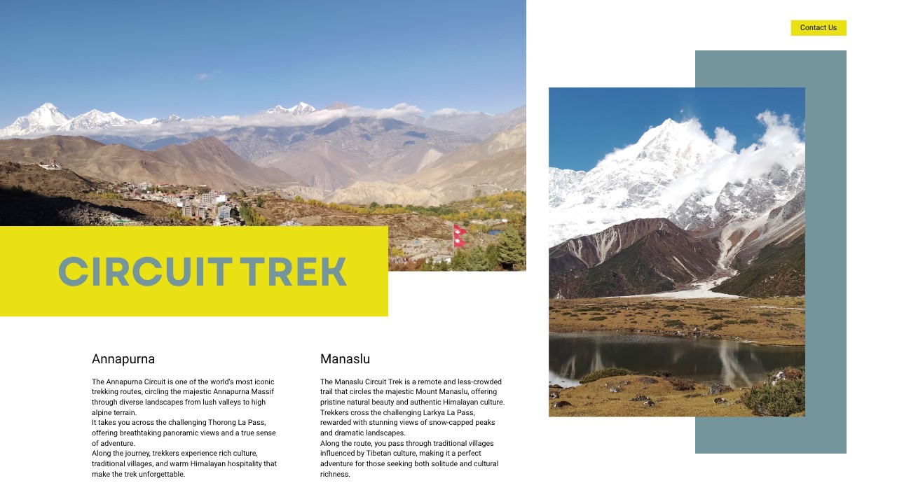
The Manaslu Circuit Trek circles Mount Manaslu (8,163 m), the world’s eighth-highest peak, in Nepal’s remote Gorkha District. Beginning at Soti Khola (710 m) near Arughat Bazaar and rising to the glaciated Larkya La Pass (5,160 m), the 177-kilometer route takes trekkers through a vertical range that stretches from subtropical river gorges to permanent snowfields in 12–17 days.
Because it falls within a Restricted Area under Nepal’s Department of Immigration, independent trekking is prohibited – all visitors require a Manaslu Restricted Area Permit (MRAP) and an Annapurna Conservation Area Permit (ACAP), and must be accompanied by a licensed guide from a registered Nepalese agency. This regulatory framework keeps annual footfall low, preserving the trail’s remote character.
Key villages along the route – Jagat, Deng, Namrung, Lho, Samagaun, and Samdo – sit within the Nubri and Tsum ethnic corridors, where communities speak Tibetan dialects and observe Nyingma Buddhist traditions. Rinji Monastery above Lho and Pungen Gumba near Samagaon are among the circuit’s most important cultural sites, rarely visited by outsiders.
Larkya La Pass (5,160 m): Challenges and Preparation
The crossing from Dharamsala (Larkya Phedi, 4,460 m) to Bimthang (3,720 m) represents the physical and psychological crux of the Manaslu Circuit. The summit day covers roughly 24 kilometers with 700 meters of ascent and 1,500 meters of descent – a commitment of 8-10 hours even for fit trekkers moving at altitude.
Acute Mountain Sickness (AMS): Ascending to over 5,000 m in a remote corridor with no road access and limited helicopter landing zones makes AMS prevention non-negotiable. Standard protocol: add an acclimatization night at Samagaon (3,530 m) or Samdo (3,875 m), maintain daily hydration above 3-4 liters, and monitor for headache, nausea, or ataxia. Diamox (acetazolamide) can be used preventively on a doctor’s advice. Any worsening of neurological symptoms requires immediate descent.
Temperature and Wind: Summit temperatures range from −15°C to −25°C with significant windchill near the pass ridge. A three-layer system – moisture-wicking base, midlayer fleece, and waterproof-breathable down shell – is the minimum standard. Most trekking groups depart Dharamsala between 3:00 AM and 4:00 AM to use stable pre-dawn air and complete the technical snowfields before solar warming destabilizes surface conditions.
Terrain Hazards: The upper section of Larkya La frequently presents compacted snow and ice, particularly during pre-monsoon (March–May) and late autumn (October–November). Microspikes or lightweight crampons are advisable; your licensed guide will assess conditions on the day. Trekking poles reduce knee strain on the long Bimthang descent significantly.
Remoteness: Unlike busier crossings such as Thorong La on the Annapurna Circuit, Larkya La has no teahouses above Dharamsala and no reliable communication infrastructure beyond satellite devices. The nearest road access from the west (Bimthang) requires a further half-day of hiking. This isolation rewards experienced, self-sufficient parties – and demands the same.
Annapurna Circuit Trek: The Classic High-Altitude Traverse
Overview
The Annapurna Circuit Trek circumnavigates the Annapurna Massif – a group of peaks including Annapurna I (8,091 m), the world’s tenth-highest mountain – through Lamjung, Manang, Mustang, and Kaski districts of Gandaki Province. The full circuit spans approximately 160–230 kilometers depending on the start and finish points chosen (Besisahar or Khudi to Nayapul or Pokhara), typically completed in 14–21 days.
Unlike the Manaslu Circuit, no special restricted-area permit is required beyond the Annapurna Conservation Area Permit (ACAP) and TIMS card. Trekkers may walk independently, though hiring a local guide remains strongly recommended.
The route passes through culturally and ecologically diverse zones: the Gurung and Magar villages of the lower valleys, the Manang District’s high-altitude landscape, and the rain-shadow semi-desert of Upper Mustang near Muktinath. Key staging settlements include Chamje, Tal, Chame, Pisang, Braga, Manang, and Thorong Phedi, before descending to the sacred Hindu and Buddhist pilgrimage site of Muktinath Temple (3,760 m) and continuing south to Jomsom, Tatopani, and ultimately Pokhara.
Thorong La Pass (5,416 m): Challenges and Preparation
At 5,416 meters, Thorong La Pass is 256 meters higher than Larkya La and the highest point on any of Nepal’s standard trekking circuits. The crossing from Thorong High Camp (4,925 m) to Muktinath typically takes 5-8 hours and involves roughly 490 meters of ascent followed by 1,600 meters of descent.
Acute Mountain Sickness: The mandatory acclimatization base is Manang (3,519 m), where trekkers should spend a minimum of two nights. Side-hikes to Ice Lake (4,600 m), Gangapurna Lake, or the Braga Monastery viewpoint are standard acclimatization activities. Several health posts and pharmacies in Manang stock Diamox, and a Himalayan Rescue Association (HRA) clinic operates seasonally, providing altitude education briefings.
Temperature and Weather: Predawn temperatures at the pass can fall below −20°C, and afternoon storms develop rapidly. Starting from Thorong High Camp no later than 4:00 AM is the accepted local standard. October and November, and March to May, offer the most stable crossing conditions, though heavy snowfall events can close the pass for 24-72 hours during any season.
Trail Condition and Navigation: The Thorong La trail is well-marked with cairns and prayer flags and carries far higher traffic than Larkya La, making route-finding straightforward in normal visibility. The technical challenge is primarily physiological rather than navigational. Emergency evacuation – by helicopter or assisted descent – is more accessible here than on the Manaslu Circuit due to proximity to Manang’s airstrip and Jomsom’s commercial airport.
Physical Demands: The summit day is shorter and less remote than the Larkya La crossing, but the higher elevation makes the AMS risk statistically greater. Infrastructure advantages (High Camp teahouses, porter availability, clear trails) make this achievable for motivated first-time high-altitude trekkers with appropriate fitness.
Head-to-Head Comparison
| Factor | Manaslu Circuit | Annapurna Circuit |
| Overall difficulty | Moderate–Strenuous | Moderate |
| Pass altitude | 5,160 m (Larkya La) | 5,416 m (Thorong La) |
| Pass crossing duration | 8–10 hours | 5–8 hours |
| Remoteness | Very remote | Well-connected |
| Permits required | MRAP + ACAP + TIMS | ACAP + TIMS |
| Independent trekking | Not permitted | Permitted |
| Teahouse infrastructure | Basic | Developed |
| Emergency evacuation | Limited access | Relatively straightforward |
| Annual trekker volume | Low (controlled) | High |
| Primary cultural corridor | Nubri / Tsum (Tibetan Buddhist) | Gurung / Thakali / Mustangi |
| Best seasons | Mar–May, Oct–Nov | Mar–May, Sep–Nov |
Which Trek Should You Choose?
Choose the Manaslu Circuit Trek if you have prior multi-day high-altitude trekking experience (ideally above 4,000 m), prefer genuine wilderness over developed infrastructure, want deep cultural immersion in rarely-visited Tibetan Buddhist communities, and are comfortable trekking in a restricted-area framework with a mandatory guide.
Choose the Annapurna Circuit Trek if you are undertaking your first major Himalayan circuit, value trail infrastructure, accommodation diversity, and flexible exit options, or need a shorter overall timeline. The presence of regular teahouses from Besisahar to Tatopani, seasonal flights from Jomsom and Manang, and the HRA clinic in Manang create a safety net unavailable on the Manaslu route.
Both treks depart from within a few hours of Kathmandu (Manaslu) or Pokhara (Annapurna), Nepal’s two primary trekking gateways. Either circuit will expose you to landscapes and communities that have no equivalent elsewhere in the Himalayas – the choice is ultimately about what kind of challenge you want, and how much support you want around you when you meet it.
Related searches: Manaslu Circuit Trek permit cost 2025, Annapurna Circuit Trek itinerary 16 days, Larkya La Pass weather conditions, Thorong La Pass difficulty, best teahouses Manang, Samagaon altitude acclimatization, Nepal trekking seasons, Himalayan Rescue Association Manang
Here’s a comparison visual to accompany the article:
| Manaslu Circuit | Annapurna Circuit |
| Gorkha District · Nubri & Tsum valleys | Manang & Mustang · Gandaki Province |
| Pass Larkya La – 5,160 m Crossing time – 8–10 hrs | Pass Thorong La – 5,416 m Crossing time – 5–8 hrs |
| Character Difficulty – Strenuous Infrastructure – Basic Independent trek – Not permitted Crowd level – Low (controlled) Circuit length – ~177 km | Character Difficulty – Moderate Infrastructure – Well-developed Independent trek – Permitted Crowd level – High (peak seasons) Circuit length – 160–230 km |